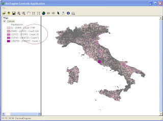
using System;
using System.Collections.Generic;
using System.Drawing;
using System.Linq;
using ESRI.ArcGIS.ADF.BaseClasses;
using ESRI.ArcGIS.Carto;
using ESRI.ArcGIS.Controls;
using ESRI.ArcGIS.Display;
using ESRI.ArcGIS.esriSystem;
using ESRI.ArcGIS.Geodatabase;
namespace Studioat.ArcEngine
{
public sealed class Classify : BaseCommand
{
private IHookHelper m_hookHelper = null;
private ITOCControl2 m_tocControl = null;
public Classify(ITOCControl2 tocControl)
{
base.m_caption = "Classify LINQ";
m_tocControl = tocControl;
try
{
string bitmapResourceName = GetType().Name + ".bmp";
base.m_bitmap = new Bitmap(GetType(), bitmapResourceName);
}
catch (Exception ex)
{
System.Diagnostics.Trace.WriteLine(ex.Message, "Invalid Bitmap");
}
}
#region Overriden Class Methods
/// <summary>
/// Occurs when this command is created
/// </summary>
/// <param name="hook">Instance of the application</param>
public override void OnCreate(object hook)
{
if (hook == null)
return;
try
{
m_hookHelper = new HookHelperClass();
m_hookHelper.Hook = hook;
if (m_hookHelper.ActiveView == null)
m_hookHelper = null;
}
catch
{
m_hookHelper = null;
}
if (m_hookHelper == null)
base.m_enabled = false;
else
base.m_enabled = true;
}
/// <summary>
/// Occurs when this command is clicked
/// </summary>
public override void OnClick()
{
//nedd to get the layer from the custom-property of the map
if (null == m_hookHelper)
return;
//get the mapControl hook
object hook = null;
if (m_hookHelper.Hook is IToolbarControl2)
{
hook = ((IToolbarControl2)m_hookHelper.Hook).Buddy;
}
else
{
hook = m_hookHelper.Hook;
}
//get the custom property from which is supposed to be the layer to be saved
object customProperty = null;
IMapControl3 mapControl = null;
if (hook is IMapControl3)
{
mapControl = (IMapControl3)hook;
customProperty = mapControl.CustomProperty;
}
else
return;
if ((null == customProperty) || !(customProperty is ILayer) || !(customProperty is IFeatureLayer))
return;
IFeatureLayer featureLayer = customProperty as IFeatureLayer;
IGeoFeatureLayer geoFeatureLayer = featureLayer as IGeoFeatureLayer;
IFeatureClass featureClass = geoFeatureLayer.DisplayFeatureClass;
string sFieldName = "Popolazione";
int numClasses = 5;
IBasicHistogram basicHistogram = new BasicTableHistogram();
ITableHistogram tableHistogram = basicHistogram as ITableHistogram;
tableHistogram.Field = sFieldName;
tableHistogram.Table = featureClass as ITable;
object oVals =new object();
object oFreqs =new object();
basicHistogram.GetHistogram(out oVals, out oFreqs);
IClassifyGEN classifyGEN = new NaturalBreaks();
classifyGEN.Classify(oVals, oFreqs, ref numClasses);
IClassBreaksRenderer render = new ClassBreaksRenderer();
double[] cb = (double[])classifyGEN.ClassBreaks;
double[] dVals = (double[])oVals;
int[] iFreqs = (int[])oFreqs;
var dValsL = dVals.Select((num, index) => new { Num = num, Index = index });
var iFreqsL = iFreqs.Select((num, index) => new { Num = num, Index = index });
var pairs = from a in dValsL join b in iFreqsL on a.Index equals b.Index select new { Values = a.Num, Frequency = b.Num };
List<int> listCount = new List<int>();
for (int i = 0; i < numClasses; i++)
{
var a = from p in pairs where ((i == 0) ? (p.Values >= cb[i]) : (p.Values > cb[i])) && p.Values <= cb[i + 1] select new { p.Frequency };
int j = a.Sum(p => p.Frequency);
listCount.Add(j);
}
render.Field = sFieldName;
render.BreakCount = numClasses;
render.MinimumBreak = cb[0];
IAlgorithmicColorRamp colorRamp = new AlgorithmicColorRamp();
colorRamp.Algorithm = esriColorRampAlgorithm.esriCIELabAlgorithm;
IRgbColor color1 = new RgbColor();
IRgbColor color2 = new RgbColor();
color1.Red = 255 ;
color1.Green = 210;
color1.Blue = 210;
color2.Red = 190;
color2.Green = 0;
color2.Blue = 170;
colorRamp.FromColor = color1;
colorRamp.ToColor = color2;
colorRamp.Size = 5 ;
bool ok = true;
colorRamp.CreateRamp (out ok);
IClassBreaksUIProperties classBreaksUIProperties = render as IClassBreaksUIProperties;
classBreaksUIProperties.ColorRamp = "Custom";
IEnumColors enumColors = colorRamp.Colors;
enumColors.Reset();
for (int i = 0;i<numClasses;i++)
{
render.set_Break(i,cb[i + 1]);
render.set_Label(i, string.Format("{0} - {1} - Count {2}", cb[i], cb[i + 1], listCount[i]));
classBreaksUIProperties.set_LowBreak(i, cb[i]);
ISimpleFillSymbol simpleFillSymbol = new SimpleFillSymbol();
simpleFillSymbol.Color = enumColors.Next();
render.set_Symbol(i,simpleFillSymbol as ISymbol);
}
geoFeatureLayer.Renderer = render as IFeatureRenderer;
mapControl.ActiveView.Refresh();
m_tocControl.Update();
}
#endregion
}
}
Qui puoi scaricare la soluzione in VS2008 ClassBreakLinq


3 commenti:
This is really nice.
I've just started using linq and just happen to be doing an automated map production solution where the classification is constantly updated.
thanks!
Hello
Do you know how to define the precision of the values used to classify ? Because the system sometimes make rounds and it has a bad effect on the classes : some records may be put in the wrong classe on the screen, or may even disappear from the lower class, because of a rounded value.
I have been searching for that but i don't find.
In avenue/arcview 3, the method was : "setprecision" for a Legend object :
myLegend.setprecision(...)
Can you set precision in desktop application?
Posta un commento