-----------------------------------

Acquista i software ArcGIS tramite Studio A&T srl, rivenditore autorizzato dei prodotti Esri.

I migliori software GIS, il miglior supporto tecnico!

I migliori software GIS, il miglior supporto tecnico!
Azienda operante nel settore GIS dal 2001, specializzata nell’utilizzo della tecnologia ArcGIS e aderente ai programmi Esri Italia Business Network ed Esri Partner Network

-----------------------------------


Visualizzazione post con etichetta ArcGIS API Google Maps. Mostra tutti i post

sabato 9 gennaio 2010

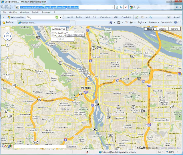
More...button

Using this sample and ESRI Google Maps API, we can show or hide tile ( TiledMapServiceLayer ) and dynamic ( DynamicMapServiceLayer ) layers.

Looking at the beginning of the file more.js in folder js, you can set the layers you want to add in the menu and you also can set other settings.
In a nutshell, to add a tile layer you have to put in layersDefinition variable an instruction such as the following:

{'type':'Tiled',
'service':'http://sampleserver1.arcgisonline.com/ArcGIS/rest/services/Portland/ESRI_LandBase_WebMercator/MapServer',
'visible':true,
'caption':'Portland LandBase',
'options':{ opacity: 0.65, minResolution: 0, maxResolution: 19 }}

service: ArcGIS Server REST resource identified url
visible: the initial visibility
caption: the caption name in the menu
options: the layer options

Instead, in order to add a dynamic layer, put a line such as the following:

{'type':'Dynamic',
'service':'http://sampleserver1.arcgisonline.com/ArcGIS/rest/services/Demographics/ESRI_Population_World/MapServer',
'visible':false,
'caption':'Population World',
'parameter':null,'opacity':0.75}

service: ArcGIS Server REST resource identified url
visible: the initial visibility
caption: the caption name in the menu
parameter: the layer parameter
opacity: the layer opacity


In this case, two layers were added (Portland Land and Population World).

To enrich the page with some more functionalities, they were drawn from Google Maps API Demo Gallery:

- Tabbed Max InfoWindow + Dynamic Content ( you can see it by clicking on a building in the town of Portland )


In the code it is easy to customize the visualization of your data following what has been done for the layer building.

- Professional DragZoomControl


-KeyDragZoom  (shift + drag )


martedì 2 giugno 2009

ArcGIS JavaScript API 1.4

E' stata rilasciata la versions 1.4 di ArcGIS JavaScript API e ArcGIS JavaScript Extension per Google Maps API. La versione 1.4 di ArcGIS JavaScript Extension per Microsoft Virtual Earth sarà disponibile a presto.
Come al solito per utilizzare le nuove versioni occorre aggiornare il tuo riferimento allo script con "v=1.4", ad esempio: http://serverapi.arcgisonline.com/jsapi/arcgis/?v=1.4.
Nuove funzionalità in in ArcGIS JavaScript API 1.4:
Routing con ArcGIS network analysis services
Supporto per mappe e geocoding forniti da Microsoft Virtual Earth
Supporto per multipli graphics layers
Class breaks e unique value renderers
Supporto per Dojo 1.3.1
prestazioni migliorate in Internet Explorer
Bug fixes

Vedi su What's New in Version 1.4 of the ArcGIS JavaScript API la lista completa dei miglioramenti. C'è anche un documento What's New per Google Maps API extension. La principale funzionalità introdotto con la versione 1.4 per ArcGIS JavaScript extensions per Google Maps API e Virtual Earth è il routing con ArcGIS network analysis services.

Vedi gli esempi live sulle funzionalità di routing:
Find routes with barriers and multiple stops
Get driving directions
Find a route

Da segnalare per il routing con Google